Introduction
According to physicist Albert Einstein "if you cannot explain it simply, you don't understand it well enough." When it comes to visualizing new transmission power facilities to support vital capacity growth in southern California, a picture is truly worth a thousand words as SCE community relations and transmission development teams paint the big picture' for all stakeholders. SCE has piloted a new design and modeling system that can literally be used to develop three dimensional (3D) renderings of how new facilities will sit in the landscape relative to their physical surroundings. This article covers the systems involved, how they've been put to use, the savings and benefits SCE has experienced, as well as some suggestions that will benefit other utilities considering similar approach.
Background
As one of the largest electric utilities in the USA and a leader in renewable energy, Southern California Edison (SCE) provides electricity service to more than 14 million people in a 50,000 square-mile area of central, coastal and Southern California. Reliable, renewable, and affordable electricity for California depends critically on a robust transmission system. SCE piloted a new 3D technology including 3D design and simulations to streamline the capital project planning and execution processes around the design, permitting and construction of large transmission systems.
SCE's transmission projects support California's renewable power goals and help deliver cleaner electricity, while also supporting system reliability to meet the region's increased demand for electricity. However, the flux of electricity markets, uncertain opportunities for profitable transmission investments, and public concerns regarding the impacts on the environment and on public health, have created a challenging environment in which to undertake transmission projects of any scale. These facts have helped drive the SCE Major Project Organization (MPO) into 3D visualization technology. But SCE MPO needed a simple solution that was fairly easy to implement and worked with the existing design and Geospatial data.
The Challenge
Historically SCE large capital transmission project teams only had two sources to envision transmission projects: engineering drawings and project mapping. Engineering drawings are difficult to communicate to outside stakeholders as the renderings are geared for engineers. Mapping - though it is easier to understand - has limited visual aspects. Given the restricting nature of these types of 2D modeling approaches - the lack of depth and lack of ability to integrate and read LIDAR (ground terrain, vegetation, roads) data, along with the amount of time and resources spent surveying out in the field - MPO realized a need for technology with greater visualization and insight that was simple to use. MPO turned to Autodesk InfraWorks 360 to create a 3D project model that could easily integrate data-rich information that was locked in the engineering world.
Senior Project Manager - "When talking about understanding the project impact, showing stakeholders the model facilitates an overall understanding and helps make better decisions. Stakeholders want to see the grading and where the towers are going to go - it's far beyond a 2D map - the visual impact is invaluable."
Potential New Platform for Stakeholder Engagement
The utility industry has always had challenges in stakeholder involvement. In McDonnell Group's 2014 Global Utility Evolution Benchmarking Study, sponsored by Autodesk, utility executives from the top 25 utilities in North America and Europe identified the top critical factors for successful capital projects. Seventy percent of participants ranked community and stakeholder involvement as top or as the second most important factor critical to the success of both utility capital projects and infrastructure investments.
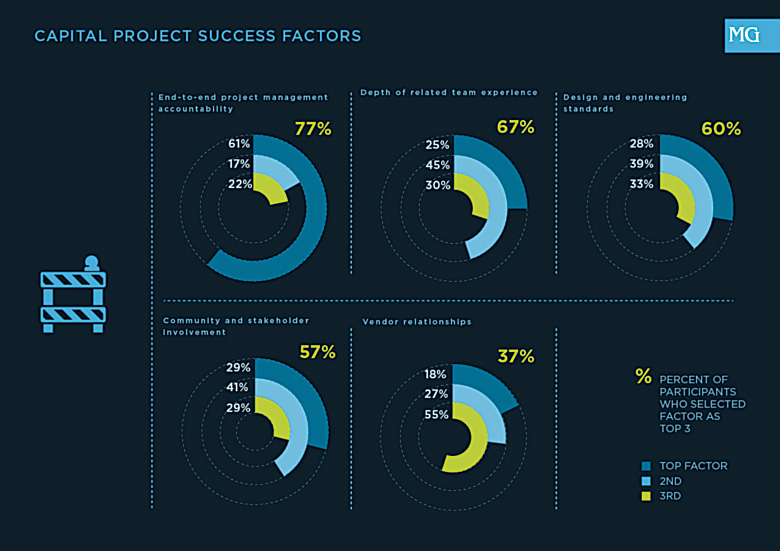
Research Graphic Courtesy McDonnell Group
(enlarge)
Southern California Edison's pilot of a new 3D visualization design and modeling toolset has shown promise in getting stakeholders to the table both internal and external. Using InfraWorks 360, internal stakeholders such as utility engineers, designers, policy makers, and regulators were able to clearly see the vision for a new project and quickly evaluate issues. The piloted 3D model was used as a common design reference across departments, and in team reviews of transmission projects by bringing together the civil design, transmission design, construction and environmental constraints data into a realistic rendering. This helped the team identify issues and take corrective action early in the project design and review cycle.
Project managers and public relations team leads also need to explain to external stakeholders the project impacts. Using 3D technologies, the extent of the project can be easily shown to reduce uncertainty in the final project build out.
In addition to a bevy of technical challenges, the planning process at any utility is subject to a host of non-technical stakeholder concerns. The interconnectedness of the transmission system means that the interests of many parties are affected both directly and indirectly by transmission planning decisions and external advocates are inevitable in projects of all sizes. 3D modeling of a project early-on can reduce issues and promote transparency, thus building public trust.
The intensity of these types of large capital projects for SCE calls for a need to easily visualize, understand and communicate transmission plans in real world context in order to effectively facilitate the public understanding necessary to reach a consensus. Greater clarity into reviewing corridor alignment alternatives results in a visual understanding of the impacts on schedule and costs. And with new transmission assets slated for a 50 year plus lifespan on the line, it's critical to keep the project development process moving forward in a timely, safe and cost-effective fashion.
SCE 3D MODEL
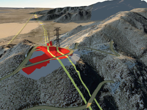
3D Model of proposed tower with grading limits (red) and limits of disturbance (gray)
3D model of proposed 220 kV tower with footing and conductor on proposed grading limit and new roads.
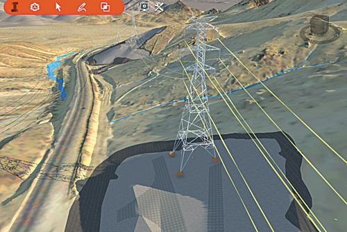
Data Input Streams & What It Takes Behind the Scenes
SCE envisions the application of 3D modeling to transform the engineering and project design workflows on capital projects. SCE's approach helped non-engineering project team members quickly and easily understand project design data in a real-world, contextual environment. The InfraWorks software allows for the quick and easy integration and layering of multiple key data sets including existing surface terrain, road, site, and other civil data, PLS-CADD data, and LIDAR (light detection and ranging), environmental, and geospatial data (GIS) data (See 3D modeling (InfraWorks) Implementation Process Graphic). The software generates a holistic, digital 3D model of the transmission project for use throughout the project lifecycle and allows for scenario modeling and comparison. SCE can leverage this technology to plan, design and engineer with real data, in the real world, in real time while potentially avoiding costly environmental issues.
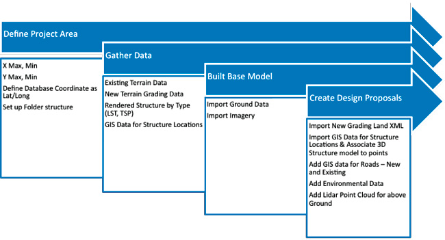
3D modeling (Infraworks) implementation Process
(enlarge)
2D vs. 3D Solutions
The ability to visualize the project design at the concept stage without having to interpret 2D engineering drawings and maps, proved valuable in the early planning stages of capital projects to explain project impacts to various SCE stakeholder groups.
Since the 3D InfraWorks model is dynamic, the project team can quickly analyze project design alternatives in the office, and potentially avoid costly field visits. The model also provides stakeholders realistic views from key observation points (KOP) perspective.
For capital projects, the bottom line is the more detailed the information, the better decisions can be made and the quicker SCE can get projects completed. The design models of existing assets, terrain, and environmental conditions can be created in hours instead of weeks, without potentially having to go to the field and aggregate data. Both the transmission and environmental teams are able to start on desktop analysis promptly saving time, resources and field trips. For SCE, it cuts down processing time and improves productivity and the ability to make informed decisions earlier in the project stage.
Conservation & Environmental Impact
SCE transmission projects can involve particularly sensitive desert, mountain, and coastal areas. One of the biggest challenges on large capital projects is assessing the impacts of project design on natural resources, and requires close attention to environmental constraints and to the conservation of wildlife- especially nesting raptors. SCE piloted the uses of the 3D modeling system to conduct virtual field visits to aid in the evaluation of design changes on the environment and to save schedule and budget. The 3D model easily incorporated environmental data and allowed project teams to foresee areas of concern for environmental impacts.
In working with the 3D model, SCE was able to have a real-world view of the location of bird nests and to evaluate impacts. In the past, nest evaluation was limited to field visit. SCE is evaluating the ability to analyze the transmission assets and various design alternatives by utilizing a point of view from a nest perspective. Furthermore, line of sight analysis can be evaluated from a nest location to determine impacts. Once a nest location is known, a nest buffer can be created that visually shows where the project components and nest buffer intersect. This can allow for better construction planning and scheduling to potentially avoid impacts to nesting birds.
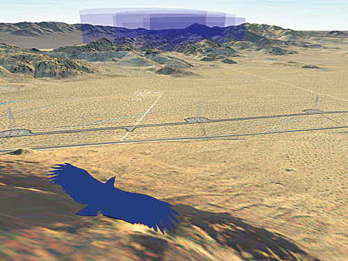
3D model visualization from nest perspective showing project components and nest buffers in the distance.
"When talking about understanding the project impact, showing stakeholders the model facilitates an overall understanding and helps make better decisions. Stakeholders want to see the grading and where the towers are going to go - it's far beyond a 2D map - the visual impact is invaluable." Marcia Carrillo
Conclusion
With plans for large investment over the next four years in expanding and strengthening SCE electric system infrastructure, the 3D modeling solution has the potential to play a major role in helping SCE design teams, clients and other stakeholders better understand projects to support timely and well-informed transmission planning and execution decisions.
Utilities seeking to build better project communications earlier in project reviews and throughout the project lifecycle, could benefit greatly from the deployment of 3D models and integrated project design business processes that leverage the cutting edge capabilities of today's newest advancements in spatial modeling. 3D transmission models have a place at the table with business benefits accruing across a range of areas including:
- Strengthened stakeholder involvement and buy-in
- Improved productivity and sharpened decision-making
- Reduced safety risks
- Enhanced ability to anticipate, analyze and reduce environmental impacts
About the Authors
 Marcia Carrillo BSEE, Ph.D. As a senior technical specialist at southern California Edison Marcia has the role of bringing innovative and best practices to large transmission projects. With over 15 years of experience in enterprise spatial data management and innovative technology solutions, she continues to devote her career to making technology work for everyone.
Contact: Marcia.carrillo@sce.com
 Daniel Hurtado is a technical specialist in transmission and distribution engineering at Southern California Edison, leading geospatial efforts at the company.