
Over the past two decades, GIS has emerged from the role of specialist application to be a key part of many utility business processes, from tracking assets and supporting the design process to feeding operational systems such as outage management and capacity planning systems. Some utilities are using GIS to support economic planning work in their state, to maintain right of way information, or to help organize more streamlined inspection and maintenance programs. But is this enough? Have organizations maximized their investment in spatial technology to provide true Enterprise GIS benefits to the organization?

Aaron Patterson
GM-Engineering
Enspiria Solutions
Enterprise GIS exists when users throughout the utility can directly and readily tap spatial data for improved decision-making – Spatial Business Intelligence. Another way of putting it: an Enterprise GIS exists when spatial data is easily and effectively used to clarify, streamline, or improve utility job tasks and business processes across the organization. Traditionally, it has been much easier, for example, to retrieve the number of times a recloser has operated from the company’s asset repository database than to create a map highlighting reclosers of a certain type shaded by the number of operations they’ve performed.
In an Enterprise GIS, the map is just as easy for users to obtain as the asset record itself and users can readily create real business value from this data. Perhaps a user wants to categorize reclosers by type and number of operations since the last inspection event, so the utility can tie in to its predictive maintenance program and create a geographically based inspection program to optimize the inspection teams’ route. When a non-GIS user can tap the spatial data to accomplish such an operation, this exemplifies Spatial Business Intelligence from the Enterprise GIS.
Enterprise GIS is an Attainable Goal
There are a number of changes in recent years that allow Enterprise GIS to be a much more attainable goal for a utility. These include:
- End User Adoption of New Technology
- Easier Deployment Options
- The Wide World of Data
End User Adoption of New Technology
Historically, the computing world has been driven by enterprise technology in the workplace. Large organizations with the capital and competition to drive their business forward invested huge sums in cutting edge technology to help them continually improve. This led to advances in computers and systems that ultimately filtered through to the wider population. E-mail is a great example of this – many adults’ first e-mail accounts were the ones they used at work – today, most people have at least one personal email account, and oftentimes more.
With the arrival of the Internet, and the increased prevalence of technology in everyday lives, consumer computing has become more of an influence in advancing technology than ever before. From the simplicity of Google’s search interface, to the instant and constant ability to connect with anyone, anywhere in the world through Instant Messaging, more and more technology is developed and fine-tuned in the consumer space, and then pushed to the enterprise.
What this shift means for utility enterprise applications is that end-users typically have experience in certain technologies that are being rolled out. In the past, a GIS user interface was a mass of complicated buttons and features that few people had any previous experience with. Today, putting a web mapping application in front of an end-user is a much less daunting experience.
A vast majority of users will have used an online mapping service at home, to get directions to a new restaurant or to find out the sales price of their neighbor’s house. This makes for a much more familiar first impression, reducing the ramp up time for each user, and ultimately the cost of deployment for the organization.
Easier Deployment Options
With the advent of technologies such as Citrix and SharePoint, deploying enterprise wide applications is now a much more standardized and attainable mission. Gone are the days of driving to every remote site to ensure the correct software version is installed on a laptop, or having remote support at each work location for when something inevitably went wrong. By centralizing the deployment and running of applications, along with utilizing security access groups that are already set up for everyone in the organization (for example, Microsoft’s Active Directory), adding access to additional users for an already deployed application is a relatively trivial exercise. This obviously depends on the computing capacity being in place to support the additional users, yet as computing power increases and hardware and storage costs continue to fall, the infrastructure costs for projects are continuing to drop.
In addition, web based GIS applications are quickly catching up to their desktop counterparts in terms of the power and functionality available. The holy grail of web mapping, editing, is now attainable using the latest software releases from a number of vendors, and the exposure of much functionality via APIs and web services mean that the majority of tasks previously only available via the large footprint desktop applications can now be pushed out to users via a web interface. Access to information on network improvement that is in progress, either in the design or build-out phase was often just accessible by the engineers and the CAD or GIS operators working on that specific job. Now utilities can publish in-progress jobs to the enterprise via a GIS web view as an integral part of their workflow with relative ease.
The Wide World of Data
In recent years, a key area of GIS expansion has been more open access to a variety of data sources. In the past, the only spatial data available was the data created and maintained internally by the organization. The concept of sharing data sources, or accessing other organizations data sources, although interesting, was not really available to any great degree, outside of some government land base data that was often of little practical use for managing an electric network dataset. However, changes in both the attitude of organizations to sharing data, along with various technological advances in the ability to serve up data on an as-needed basis have resulted in new opportunities for organizations to pull in both internal and external data that can be useful to their business.
Previously, interesting and useful data had to be loaded internally to a GIS database prior to being able to be used effectively to support decision-making. This is no longer the case. Accessing data services, such as real-time weather feeds, demographic data, or “street view” photography is now widely available from various vendors, opening up a whole new set of questions that can be answered by the GIS. In addition, the fact that this data is accessed “live” allows for vendors to refresh whole datasets and make those available to their customers without the distribution issues of the past, where CDs or hard drives had to be shipped out.
This is especially pertinent in emergency situations such as hurricanes, where often times updated satellite imagery is available in a relatively short period of time, allowing a high level view of storm damage to the utility operations center.
When these changes in behavior and advances in technology are tapped to extend GIS functionality across the enterprise, utilities gain measurable benefits. Extending the use of spatial data into other parts of the utility organization that don’t traditionally use GIS is a key step along the way toward achieving Enterprise GIS. The following describes two areas in which utilities are using Spatial Business Intelligence to improve their decision making, expanding both their GIS user base and GIS data: Outage Communication & Planning, and Advanced Metering Infrastructure (AMI) Deployment Planning.
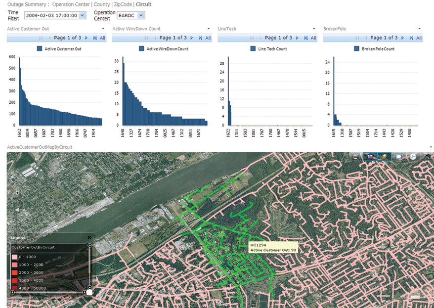
Sample Outage Dashboard with Thematic Charting by Circuit
Outage Communication & Planning
A critical area for every electric utility is their performance in response to a major outage event. Ensuring safety, maintaining critical customers and returning power as quickly as possible are all key goals for a utility.
Where are the network issues? Where are my crews? How long before the storm moves out of my service territory? How long before I get the right equipment to the right location? These are just some examples of the questions that need to be answered to solve the multitude of problems a large-scale outage creates. And the availability of relevant and timely information, tailored to specific groups of users, can make the difference between hitting targets for restoration, or not.
Under the concept of Enterprise GIS, utility users can directly and readily tap spatial data for improved outage processes and decision making, in real time as the storm is taking place and/or after the outage to improve performance for the next time. By overlaying near real-time outage information over the utility’s network data, and allowing end users to view both high level and detailed information as it comes in, utilities can address issues from a more pro-active level as the outage develops.
Data to support this decision making process comes from various systems, including the outage management, work management and mobile workforce management systems internally, along with weather feed information externally. This data was never previously integrated with other spatial data sources, despite often having some spatial component or tie-in that can be used, be it zip code, address, or network name for example. GIS applications can use this spatial component to geocode incoming data “on the fly” for visual display.
By deploying the outage communications and planning capabilities on a web based Intranet infrastructure, critical event data can be communicated more effectively to more of the organization during stressful outage responses. This is especially useful to get answers as they relate to the overall picture of a particular outage – for example:
- Did the volume of customer calls increase or decrease in the last hour?
- Are particular counties being worse hit than others, and do I have the right crew balance) to address this?
- Are all of my wire-down situations correctly staffed?
A key aspect to capturing this data is the ability to take a temporal view, and actually replay specific major events at some point in the future as if they were happening live. This capability allows users to be trained using actual historical storm data from a past event, as well as a providing the platform to review a utility’s performance in the cold light of day, helping to improve standard operating procedures before the next event arrives.
Tapping Enterprise GIS capabilities for outage communications and planning bring a number of benefits to the utility, including:
- Better tactical information with which to make restoration decisions,
- Providing outage information to a wider set of decision makers/users,
- Improved communications with consumers and other external parties,
- Providing a systematic way of analyzing the data after the storm is complete,
- Making better strategic and planning decisions to prepare for the next event, and
- Providing training opportunities for both new and experienced staff.
AMI Deployment Planning
Deploying advanced meters is a major component of most major Smart Grid projects, providing the fundamental communication from the customer to the utility in “near” real-time. Meters, and the communication networks to support them, are the major cost component in a project of this type. Utilities are now able to use Enterprise GIS functionality to optimize meter deployment, providing positive impacts on the overall Smart Grid Business Case. Utilities can optimally develop their deployment strategy based on, for example, geography, hard to access accounts, age of infrastructure, demographics, meter/regulator types, political considerations, and cost to serve.
Enterprise GIS functionality and the associated spatial intelligence can be tapped for AMI deployment planning including for…
- Technology Optimization – The determination of meter density mapping across the service territory.
- Initial Deployment Area Selection – Mapping meter density across the service territory AND mapping of multiple attributes to identify optimal potential initial deployment locations. This is useful during an initial field trial or pilot phase to plan installation of meters across a wide selection of customer types and physical locations while also taking into account such things as socio-economic factors.
- Full Deployment Sequencing – Mapping meter density across the service territory AND mapping multiple weighted benefits attributes to identify a deployment sequence that will maximize Return on Investment (ROI).
By identifying specific endpoint characteristics and their physical locations within a utility’s service territory, potential benefit groupings can be identified. Using the GIS, combined with available datasets, both internal and external, areas and locations of highest potential benefits can be identified and targeted for early deployment. Some examples of benefits and corresponding data utilized in analysis include:
- Meter Reading Cost Reduction – Hard to access meters, high turnover, high number of billing complaints/disputes, inside meters
- Density – Urban, suburban, rural, multi-units
- Revenue Protection – Endpoints with collection problems, high turnover, distressed areas, history of tampering
This capability allows the utility to target selected populations for technology deployment. Benefits gained from this use of Enterprise GIS include:
- For pilot testing, the ability to identify a geographic area that represents the desired technical challenges and potential benefits
- Facilitating identification of customers with the potential to deliver benefits in excess of the general population.
- Maximizing a utility’s ROI by providing higher performing benefits early in the deployment cycle
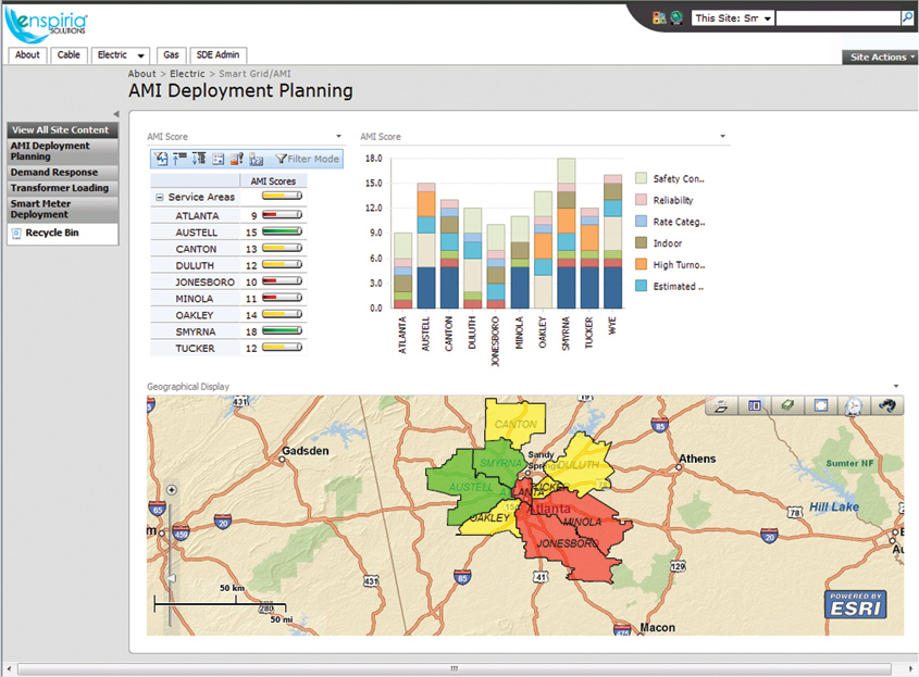
AMI Deployment Planning Dashboard for Initial Deployment Selection
In Summary
Although GIS has entered the mainstream at many utilities and is becoming an increasingly critical part of the information infrastructure, continuing developments in end-user adoption, technology and data have allowed progressive organizations to continue to expand the role of Spatial Business Intelligence in the decision making process. Continuing to look for opportunities to utilize spatial data and your Enterprise GIS in new ways will offer continuing progress in the never ending drive for more efficient and effective business intelligence and decision making.
About the Author
Aaron Patterson is General Manager of Engineering at Enspiria Solutions, Inc. Mr. Patterson has been involved in architecting, designing, developing and delivering large-scale systems for utility companies around the world for over 15 years. His expertise spans Geographical Information Systems, Service Oriented Architecture and utility integration. Mr. Patterson holds a BS degree in Business Information Technology from the University of Northumbria, United Kingdom. Aaron Patterson can be reached at apatterson@enspiria.com.