
Prudent vegetation management, as applied to electric power transmission, embodies prudent risk management. Specifically, the prudent vegetation manager answers the following two questions in the affirmative – “YES.”
- Does the vegetation management program provide the minimum allowable clearance between the transmission line and the vegetation on the right-of-way?
- Does the vegetation on the right-of-way allow workers a clear pathway to patrol, upgrade, and/or repair transmission system components?
In the questions above, the term ‘right-of-way’ means “the corridor of land under (and adjacent to) a transmission line needed to operate the line (reliably)” – NERC Standard FAC 003-2 definition – reference for italicized text/quote throughout. If indeed the answer turns out to be “NO,” then it will not take very long (sense of urgency) before the transmission line becomes unreliable (consequence).
Observation: In the recent past, much has been written about what happens when either one or both of the answers to the questions is “NO.” In such a circumstance, the transmission line owner may have operated under a:
- ‘Risk Avoidance’ strategy – not performing an activity that could carry risk
- ‘Risk Sharing/Transfer’ strategy – sharing/transferring the burden of loss with another party (the customer or the contractor)
- ‘Risk Retention’ strategy – accepting the loss
Each of these risk/vegetation management strategies has been found by experience to be totally unacceptable – all mistaken beliefs that the owner can avoid, share/transfer, or accept such a significant loss unilaterally.
Conclusion: Over time, the standards and guidelines for improving and/or maintaining transmission reliability have evolved. The risk/vegetation management strategy of choice evolved also, evolving from a) ‘Risk/Hazard Prevention’ (e.g., the total elimination of risks/hazards takes too long, is too costly, or is otherwise impractical as it only leads to mitigation of unfound hazards) to b) ‘Risk Reduction’ (e.g., reducing the consequence [severity of loss] and/or the sense of urgency [likelihood of the loss occurring]). Ample evidence to support this conclusion can be found in the recent referenced literature:
- FERC Frequently Asked Questions (FAQS)
http://www.ferc.gov/help/faqs/tree-veget.asp - FERC: Tree Trimming & Vegetation Management
http://www.ferc.gov/industries/electric/indus-act/reliability/vegetation-mgt.asp - Steptoe & Johnson PLLC: Power Line Rights of Way – FERC Approves New Vegetation Management Rules
http://www.lexisnexis.com/legalnewsroom/environmental/b/oil-gas-energy-law/archive/2013/03/29/steptoe-amp-johnson-pllc-power-line-rights-of-way-ferc-approves-new-vegetation-management-rules.aspx
Accepting a strategy of ‘Risk Reduction’, vegetation managers turned their attention to implementation (e.g., take proactive steps of risk management). The proactive steps of risk/ vegetation management may include the following – not necessarily accomplished in this explicit order:
- Inspection
- Detect, identify, and locate the hazardous vegetation
- Assess the hazards to determine the level of risk
- Plan the work (establish controls and make risk decisions)
- Manage the work (implement controls through supervision and measurement)
- Audit the work (evaluate)
- Report (cost and regulatory reporting)
As pointed out by Steptoe & Johnson PLLC [3], the latest FERC vegetation management standard “does not apply to circumstances that are beyond the control of a Transmission Owner subject to this reliability standard.” For example, out-of-the-ordinary weather events often create circumstances that render ineffective even the most well-intentioned, proactive efforts to reduce risks. Notwithstanding,
- If the transmission owner’s goal is to reduce the likelihood of occurrence and/or the consequence of a risk actually occurring, then by FERC standard the owner is to invoke “prudent vegetation management practices (which) dictate that substantially greater distances (than the applicable minimum vegetation clearance distance) will be achieved at the time of vegetation maintenance.”
- If this goal is to be achieved, then vegetation located both inside and outside the designated right-of-way boundary must be considered – within an effective corridor width (e.g., the width of the corridor is established by engineering or construction standards as documented in either construction documents, pre- 2007 vegetation maintenance records, or by the blowout standards in effect when the line was built), which “in no case exceeds the Transmission Owner’s legal rights.” Thus, the effective corridor width, for vegetation management purposes, may yet to be established – at least in some cases.
One real example of prudent practice when faced by circumstances beyond the control of a transmission owner, an ice storm, validates both the current revised version of the FERC standard as well as new tools aimed at servicing those standards. The ice storm occurred along the corridor of El Paso Electric’s Arizona Interconnection 345kV Tie Line during the winter of 2010 to 2011. The affected section of the ‘Springerville line’ runs from the vicinity of Winston, NM/Montecillo, NM northwest toward the vicinity of Springerville, AZ. The terrain is rough as the corridor moves from a relatively flat desert type environment (moderate to sparse shorter, brush vegetation) up to higher desert plateaus (moderate to dense, tall Ponderosa Pine) of NW New Mexico.
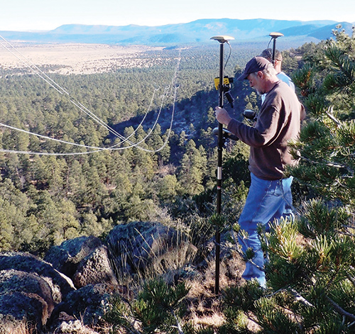
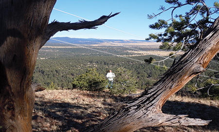
Detecting vegetation violations from a central location in a span1
El Paso Electric had engineered the line to take into account at least 1. inches of ice on the conductor. During the ice storm, the line experienced between 2 and 3 inches of ice. Such ice loading conditions forced contact between the energized line and vegetation in multiple areas even though prudent vegetation management practices had been in place for years prior to the event.
Since the Springerville line ran through Bureau of Land Management (BLM) land, multiple stakeholders were interested in seeing that deliberate action was taken immediately to resolve the problem and prevent it from occurring again in the future. El Paso Electric needed to gain the confidence of the various stakeholders and keep it.
El Paso Electric elected to:
- Capture airborne LIDAR along the affected length of the Springerville line
- Construct a PLS-CAD model of the line
- Determine (identify and locate) the inventory of vegetation clearance violations caused by the ice storm and deal with (resolve) each violation in a way that was measurable repeatable, and verifiable
To facilitate the analysis work, Darwin Jensen (El Paso Electric’s transmission engineer) chose a corridor wider than the legal right-of-way boundaries to account for tall trees falling from outside the right-of-way. He analyzed the conductor operating conditions considering both the existing ice loading conditions as well as the established maximum sag conditions. The vegetation clearance criteria specified was substantially greater than the minimum allowable clearance distance.
To facilitate the clearing work, Ryan Paulk (El Paso Electric’s transmission forester) made effective use of Aerotec’s TopGun Veg-Tool. The instrument was loaded with:
- The vegetation violations inventory to serve as a personal navigator
- The clearance criteria
- The specific conductor loading conditions to facilitate on-the-spot analysis of specific vegetation points of interest (e.g., trees)
As it turns out, El Paso Electric effectively addressed/ satisfied most, if not all, of the requirements specified in the current version of the FERC standard a couple of years before the standard came into being. Indeed, care was taken to assure that the available airborne LIDAR data covered sufficient corridor width required to detect, identify, and locate vegetation that would violate the “substantially greater (violation) clearance distances” employed by El Paso Electric.
The results were completely satisfactory to all involved, to the extent that a previous article was published (Electric Energy/Summer 2011) describing actual experiences with the process, technology, and tools used. The article is entitled LIDAR Technology and Handheld Vegetation Management Device Aid Transmission Group at El Paso Electric. El Paso Electric’s approach serves as a good example of the application of a Risk Reduction strategy. The technology, tools, and standards have certainly evolved to better serve El Paso Electric and others as time has passed since the ice storm; and other utilities are seriously contemplating the use of this new technology for their work.
Opportunity: During the past couple of years, NERC prompted a transmission line re-rating study that was generally focused on transmission lines of higher voltage (e.g., 200kV and higher) and the revised FERC standard applies both to these ‘NERC’ re-rated lines and explicitly to any lower voltage overhead transmission line that is either an element of an Interconnection Reliability Operating Limit (IROL) or an element of a Major WECC Transfer Path. For any additional IROL/WECC lines, new PLS-CADD models may need to be constructed to facilitate the detection, identification, and location of hazard vegetation. This does NOT necessarily mean that additional airborne LIDAR data needs to be collected and PLS-CADD models can be constructed from Plan/Profile drawings. This is an important point to take note of.
As El Paso Electric discovered, Aerotec’s methods/tools promote recurring use of right-of-way geometry data (via the TopGun Veg-Tool data model) to facilitate the forester’s own inspection of right-of-way vegetation from the ground with or without airborne LIDAR data. The forester’s use/adoption of the device even solves the problem posed by ‘missing’ airborne LIDAR data beyond the edge of the right-of-way width designated for LIDAR data capture for NERC’s line re-rating studies.
As a further benefit to El Paso Electric, while the FERC order requires that a transmission owner is now required to annually inspect all transmission lines subject to the standard; there is no need to refly transmission lines to capture new airborne LIDAR data annually just to satisfy the revised standard. Using the Veg-Tool, El Paso Electric’s forester can simply (and accurately) perform an on-the-ground inspection to update earlier inspection results and thus satisfy this requirement year after year.
Prudent practice is also on the minds of Alabama Power Company (APCo). The utility is now preparing to use the TopGun Veg-Tool to define the ‘in-service’ right-of-way for green-field transmission projects. The current effort involves the construction of a new 60-mile transmission line alongside an existing transmission line/right-of-way. James Weninegar, APCo transmission engineering manager, intends that hazard trees, along and beyond the planned/legal right-of-way boundary, will be identified, analyzed, and located using the technology to negotiate cutting rights with the land owners. Further, it is his intent that:
- The identified hazard trees will be ‘marked,’ early in the line design process, using the GIS recording capabilities of the Veg-Tool for future use in clearing operations.
- The Veg-Tool data model will constitute an ‘in-service’ definition of the transmission corridor for future vegetation management work (e.g., inspection and/or audit).
Mr. Weninegar fully recognizes the data model as a semi-permanent asset that can be used again and again, well into the future, to support subsequent inspection operations without the need for additional airborne LIDAR data capture. As he stated, “Unless we redefine the right-of-way, alter the conductor geometry, change our clearance criteria, or alter our conductor operating conditions, we can just keep on using the TopGun Veg-Tool for our inspections.”
Additionally, Mr. Weninegar intends to construct an ‘in-service’ version of the transmission corridor (e.g., TopGun Veg-Tool data model) for each line of a larger portion of APCo’s higher voltage transmission system and use the tool for future vegetation management inspections and audits as APCo implements the revised FERC standard. Mr. Weninegar is relying on his vast experience in the engineering, maintenance, vegetation management, and operation of electric power transmission lines supported by his prior use of airborne LIDAR and other types of remote sensing to envision success in the construction and use of his ‘in-service’ transmission corridor models.
Overall, Aerotec’s TopGun Veg-Tool is an easy-to-use,2 lightweight, versatile, single-operator, flexible handheld device that, from a single spot within a given span of an electric power transmission line, can be used to take ‘single shot’ measurements of multiple suspect trees, both inside and outside span boundaries, to:
- Provide accurate and easy-to-read (PASS/FAIL) vegetation clearance information. While performing the field inspection task, the forester uses the device to:
- Designate (shoot) and identify (analyze) suspect vegetation as a violation of specific (one or more) clearance criteria based on risk levels (urgency), and multiple conductor operating conditions. Default to multiple geographic boundaries, and multiple clearance violation types.
- Locate the specific vegetation violation(s) for purposes of marking/flagging offending trees, auditing the site, reporting work progress, and re-inspection going forward.
- Communicate violation(s) type, characteristics, and location using a camera, cellular phone, and SD storage card.
- Collect other specific information about vegetation violating clearance criteria, such as stem diameter at breast height, species, growth observations year-to-year, and so on.
- Package the analysis results and associated observations/ measurements (shape file) for geographical information system (GIS) database population/update, as may be required.
The device integrates several unique technologies into a lightweight surveyor’s staff configuration for ease of use in the field work environment. Included are a handheld laser rangefinder, compass and inclinometer as well as a handheld computer with Bluetooth, GPS positioning capability, digital camera, and cellular phone. The software comprises a GIS and Aerotec’s own vegetation management software and right-of-way model.
The tool is useful to every type of electric utility and can be applied to transmission and distribution rights-of-way (the right-of-way geometry model can be derived from existing Plan & Profile Drawings, PLS-CADD Models, and/or LIDAR data). This can reduce the need to have the right-of-way flown for acquiring LIDAR in order to produce the geometry data model and the existence of a PLS_CADD model expedites the process of constructing the data model (right-of-way geometry) while accounting for multiple conductor operating conditions. In addition, Plan/Profile drawings may be used to create the data model. It is NOT necessary to have an existing inventory of clearance violations previously derived from LIDAR data in order to make effective use of the technology. Because customer-specific vegetation clearance criteria for various conductor operating conditions are required, Aerotec’s vegetation assessment capabilities can support customers’ efforts to refine vegetation clearance criteria in order to achieve specific objectives pertinent to their vegetation management program.
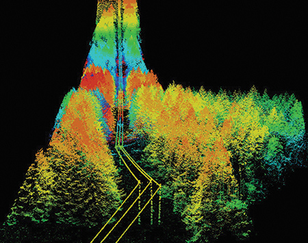
Airborne LIDAR data of an existing right-of-way
The most efficient, cost-effective and accurate approach for taking advantage of the tool is to have:
- Existing LIDAR data/PLS-CADD model(s) for the right-of-way
- Aerotec produced the right-of-way geometry model, an inventory of vegetation violations, and a TopGun Veg-Tool data model (complete with a clearance surface map accommodating multiple conductor operating conditions) along the entire right-of-way
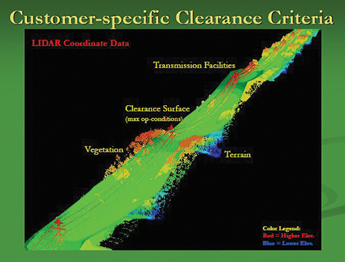
Three dimensional model of a customer’s clearance criteria.
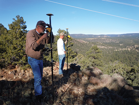
Cataloging vegetation clearance violations in rough terrain
The tool adds considerable capabilities to a utility. Right ‘out-of-the-box’ it increases the productivity, effectiveness, and efficiency of the utility forester.
The TopGun Veg-Tool is light weight and rugged.
Gathering the amount of data required to accurately identify, locate, analyze, and report vegetation clearance violations remotely (at any time of the year) is possible due to the ability to:
- Capture (single-shot) measurements to vegetation features without the need for a reflector (e.g., a person holding a prism pole)
- Enable the forester to carry the entire geometry of the right-of-way (along with the entire LIDAR-derived inventory of vegetation violations), the geometry of the structures/conductors, the critical conductor operating conditions, and appropriate clearance criteria to the field – to process/analyze single-shot measurements (TruPulse 360) using the TopCon GRS-1 handheld computer. It is not necessary for the forester to ‘shoot’ either the base of the target tree (which may or may not be visible) or the transmission line conductor
The TopGun Veg-Tool:
- Affords the electric utility a tool to address all aspects of FERC Standard FAC-003-2 Technical Reference compliance requirements
- Data model is a semi-permanent asset that can be used year-after-year, well into the future and the data model only needs to be updated if:
- The clearance criteria is updated
- The geometry of the right-of-way changes
- The conductor operating conditions being analyzed are changed
A useful accessory for the forester in the field is the TopGun Tablet. The personal navigation, inspection, auditing, and reporting tool offers a larger screen. The user can accomplish the same inspection/audit tasks. The GPS-enabled tablet does not necessarily employ the laser range finder; but it makes use of the data model’s clearance surfaces to present a contour map(s) of the clearance surface(s) to highlight the allowable vegetation height-above-ground enabling the forester to identify, locate, and report a clearance violation.
After the forester has identified, analyzed, and located (or ‘marked’) the vegetation violations (whether or not aided by the use of an airborne LIDAR violation inventory), the actual clearing work can be planned and tasked out, e.g., work management. To support work management, Aerotec offers other effective tools operating in a GIS environment.
It is simply not enough to visualize the inventory of violations (whether originating from LIDAR or otherwise) using some form of visualization aid – whether it might be Google Maps, Google Earth, or some other display technique. Users really do have to pay for those licenses and endure the significant analytical limitations of the software. Real work management is required; and this does not mean just ‘scheduling.’ Work management involves:
- Categorizing the work according to type of work
- Assessing the difficulty of traversing the terrain
- Assigning crews equipped with special tools
- Getting the crews to the work site
- Assessing the potential impact of weather
- Tracking vehicles/crews as may be required
- Reporting real-time events/issues
- Tracking work status, and more
Foresters don’t just marvel (look) at their data, they facilitate the accomplishment of real work and ensure that the quality/quantity of the work is adequate to meet standards – in more than a ‘just good enough’ manner. Foresters need real, functional tools to accomplish their work.
All-in-all, the utility forester is committed to focusing on the results required to facilitate prudent vegetation management – period! It’s important to know where to look for hazards; but it is equally important to know where you don’t have to look for hazards.
About the Author
 James W. Dow was an original founder of Aerotec, LLC (airborne remote sensing) in 1996, having retired from the Alabama Power Company as Manager of Information Resources Plans and Projects. Mr. Dow is generally acknowledged as one of the most influential engineers in the United States regarding CAD/CAM/CAE technology and LIDAR ‘filtering’ software development. Mr. Dow has over twenty-five years of experience in application software development and support for a variety of industries that include military defense, aerospace, forest products, construction, communications, and electric utility.
Mr. Dow’s experience spans all aspects of information management methodology/technology from strategic planning for network-infrastructure through design, engineering, construction, implementation, and support of mission critical computer application systems across multi-company/multi-state political and geographic areas. He has a BS and MS, Aerospace Engineering and has graduated from Virginia Polytechnical Institute in Advanced Particle Dynamics.
In 1979, Mr. Dow co-authored an internationally acclaimed book entitled. “The Guide for the Evaluation and Implementation of CAD/CAM Systems.” He played a key role in bringing several successful European CAD/CAM software products to the U.S. marketplace.
1 The photographs contained in this article were taken in the field while the actual work for El Paso Electric was being performed.
2 Initial training for a utility forester to effectively use the TopGun Veg-Tool takes about two hours, even in very rugged terrain, involving instrument calibration, start-up, field use (measurements and analysis), data download, data model handling, and archiving results.